- Splunk Answers
- :
- Using Splunk
- :
- Dashboards & Visualizations
- :
- Geospatial lookup returns wrong results
- Subscribe to RSS Feed
- Mark Topic as New
- Mark Topic as Read
- Float this Topic for Current User
- Bookmark Topic
- Subscribe to Topic
- Mute Topic
- Printer Friendly Page
- Mark as New
- Bookmark Message
- Subscribe to Message
- Mute Message
- Subscribe to RSS Feed
- Permalink
- Report Inappropriate Content
Geospatial lookup returns wrong results
Hi everyone,
I have a problem with identifying if a point is within a polygon or not.
For the same latitude and longitude, sometimes I get right results, but sometimes not. I get wrong results if I search for more IDs (so there are more events) or I change the time range (not necessarily bigger).
The line which causes the issue: | lookup some_lookup_name latitude longitude


Thanks in advance 🙂
- Mark as New
- Bookmark Message
- Subscribe to Message
- Mute Message
- Subscribe to RSS Feed
- Permalink
- Report Inappropriate Content
Hi @friderikab,
It is not possible to guess without seeing your search, could you please show your search? How do you pass latitude longitude fields to lookup?
- Mark as New
- Bookmark Message
- Subscribe to Message
- Mute Message
- Subscribe to RSS Feed
- Permalink
- Report Inappropriate Content
Hi,
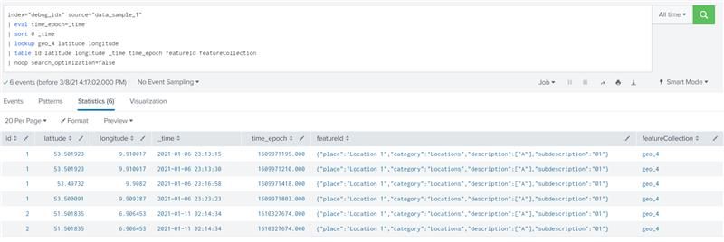
We have reproduced the issue with sample data and simple geospatial lookup. All events with id=1 are inside the geofence, events with id=2 are outside. We are getting incorrect results (different when sorting according to time). We have two sample data sources (data_sample_2 has changed latitude in one of the events for id=2, from 51.501835 to 51.501836).
When sorting from earliest to latest, all events are inside:
When sorting from latest to earliest, some events for id=1 are outside (which is incorrect):
Removing event with problematic latitude:
Search:
index="debug_idx" source="data_sample_1"
| eval time_epoch=_time
| sort 0 _time
| lookup geo_4 latitude longitude
| table id latitude longitude _time time_epoch featureId featureCollection
| noop search_optimization=false
Data_sample_1:
{"location":{"state":{"position":{"timestamp":"2021-01-11T01:14:34.000Z","latitude":51.501835,"longitude":6.906453}}},"ident":{"attr":{"id":"2"}}}}
{"location":{"state":{"position":{"timestamp":"2021-01-11T01:14:34.000Z","latitude":51.501835,"longitude":6.906453}}},"ident":{"attr":{"id":"2"}}}}
{"location":{"state":{"position":{"timestamp":"2021-01-06T22:23:23.000Z","latitude":53.500091,"longitude":9.909387}}},"ident":{"attr":{"id":"1"}}}}
{"location":{"state":{"position":{"timestamp":"2021-01-06T22:16:58.000Z","latitude":53.49732,"longitude":9.9082}}},"ident":{"attr":{"id":"1"}}}}
{"location":{"state":{"position":{"timestamp":"2021-01-06T22:13:30.000Z","latitude":53.501923,"longitude":9.910017}}},"ident":{"attr":{"id":"1"}}}}
{"location":{"state":{"position":{"timestamp":"2021-01-06T22:13:15.000Z","latitude":53.501923,"longitude":9.910017}}},"ident":{"attr":{"id":"1"}}}}
Data_sample_2:
{"location":{"state":{"position":{"timestamp":"2021-01-11T01:14:34.000Z","latitude":51.501836,"longitude":6.906453}}},"ident":{"attr":{"id":"2"}}}}
{"location":{"state":{"position":{"timestamp":"2021-01-11T01:14:34.000Z","latitude":51.501835,"longitude":6.906453}}},"ident":{"attr":{"id":"2"}}}}
{"location":{"state":{"position":{"timestamp":"2021-01-06T22:23:23.000Z","latitude":53.500091,"longitude":9.909387}}},"ident":{"attr":{"id":"1"}}}}
{"location":{"state":{"position":{"timestamp":"2021-01-06T22:16:58.000Z","latitude":53.49732,"longitude":9.9082}}},"ident":{"attr":{"id":"1"}}}}
{"location":{"state":{"position":{"timestamp":"2021-01-06T22:13:30.000Z","latitude":53.501923,"longitude":9.910017}}},"ident":{"attr":{"id":"1"}}}}
{"location":{"state":{"position":{"timestamp":"2021-01-06T22:13:15.000Z","latitude":53.501923,"longitude":9.910017}}},"ident":{"attr":{"id":"1"}}}}
Geolookup_4.kml
<?xml version="1.0" encoding="utf-8" ?>
<kml xmlns="http://www.opengis.net/kml/2.2">
<Document id="root_doc">
<Schema name="geo_4" id="geo_4">
	<SimpleField name="Name" type="string"></SimpleField>
</Schema>
<Folder>
<name>geo_4</name>
<Placemark>
    <name>{"place":"Location 1","category":"Locations","description":["A"],"subdescription":"01"}</name>
    <Style><LineStyle><color>ff0000ff</color></LineStyle><PolyStyle><fill>0</fill></PolyStyle></Style>
    <Polygon><outerBoundaryIs><LinearRing><coordinates>9.92195,53.51249 9.92848,53.49588 9.89352,53.49482 9.89561,53.51567 9.92195,53.51249</coordinates></LinearRing></outerBoundaryIs></Polygon>
</Placemark>
</Folder>
</Document></kml>


